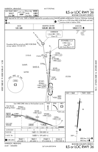
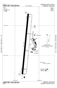


KHRO - Boone County
Located in Harrison, United States
ICAO - HRO, IATA - HRO
Data provided by AirmateGeneral information
Coordinates: N36°15'41" W93°9'17"
Elevation is 1364 feet MSL.
Magnetic variation is 04° East View others Airports in Arkansas
Operational data
Special qualification required
Current time UTC:
Current local time:
Weather
METAR: KHRO 082353Z AUTO 18006KT 9SM FEW055 26/19 A2957 RMK AO2 LTG DSNT N AND NW SLP001 T02560194 10283 20256 53004
TAF: KHRO 082320Z 0900/0924 20010KT P6SM VCTS FEW030CB TEMPO 0901/0904 28025G40KT 1SM +TSRA BR OVC020CB FM090400 29007KT P6SM -SHRA OVC050 FM090600 30007KT P6SM SCT250 FM091800 32009G17KT P6SM FEW250
Communications frequencies: [VIEW]
Runways:
| RWY identifier | QFU | Length (ft) | Width (ft) | Surface | LDA (ft) |
| 18 | 186° | 6161 | 150 | ASPH | |
| 36 | 6° | 6161 | 150 | ASPH |
Airport contact information
Address: Harrison United States