


KHIB - Range Rgnl
Located in Hibbing, United States
ICAO - HIB, IATA - HIB
Data provided by AirmateGeneral information
Coordinates: N47°23'12" W92°50'20"
Elevation is 1353 feet MSL.
Magnetic variation is 02° East View others Airports in Minnesota
Operational data
Special qualification required
Current time UTC:
Current local time:
Weather
METAR: KHIB 280353Z AUTO 35007KT 10SM BKN022 OVC029 06/03 A3003 RMK AO2 SLP180 T00560033
TAF: KHIB 272325Z 2800/2824 35011G18KT P6SM BKN014 OVC021 FM280700 02008G15KT P6SM OVC009 FM281200 05009KT P6SM OVC007 FM281500 07010G18KT P6SM OVC011 FM281800 08013G22KT P6SM OVC022
Communications frequencies: [VIEW]
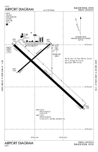
Runways:
| RWY identifier | QFU | Length (ft) | Width (ft) | Surface | LDA (ft) |
| 04 | 49° | 3075 | 75 | ASPH | 3075 |
| 22 | 229° | 3075 | 75 | ASPH | 3075 |
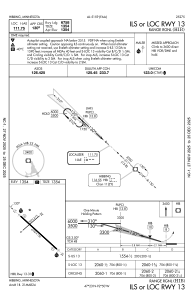
| 13 | 132° | 6758 | 150 | ASPH | 6758 |
| 31 | 312° | 6758 | 150 | ASPH | 6758 |
Airport contact information
Address: Hibbing United States