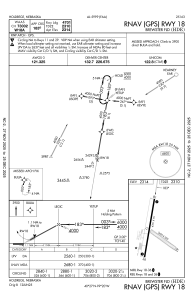


KHDE - Brewster Fld
Located in Holdrege, United States
ICAO - HDE, IATA -
Data provided by AirmateGeneral information
Coordinates: N40°27'7" W99°20'10"
Elevation is 2313 feet MSL.
Magnetic variation is 07° East View others Airports in Nebraska
Operational data
Special qualification required
Current time UTC:
Current local time:
Weather
METAR: KHDE 021955Z AUTO 34016G22KT 10SM CLR 18/03 A2987 RMK AO2 T01840031
Communications frequencies: [VIEW]
Runways:
| RWY identifier | QFU | Length (ft) | Width (ft) | Surface | LDA (ft) |
| 11 | 126° | 2429 | 300 | GRASS | |
| 29 | 306° | 2429 | 300 | GRASS | |
| 18 | 190° | 4701 | 75 | OTHER | |
| 36 | 10° | 4701 | 75 | OTHER |
Airport contact information
Address: Holdrege United States