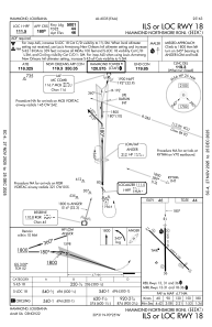
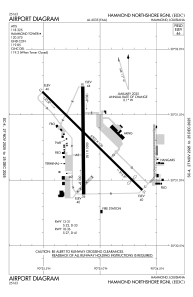


KHDC - Hammond Northshore Rgnl
Located in Hammond, United States
ICAO - HDC, IATA -
Data provided by AirmateGeneral information
Coordinates: N30°31'18" W90°25'6"
Elevation is 46 feet MSL.
Magnetic variation is 00° East View others Airports in Louisiana
Operational data
Special qualification required
Current time UTC:
Current local time:
Weather
METAR: KHDC 281735Z AUTO 14018G26KT 10SM BKN026 OVC033 26/20 A3006 RMK AO2 T02640204
TAF: KHDC 281727Z 2818/2918 14020G30KT P6SM BKN025 FM290300 14016G25KT P6SM BKN015 FM291500 17012G19KT 5SM -TSRA OVC015CB
Communications frequencies: [VIEW]
Runways:
| RWY identifier | QFU | Length (ft) | Width (ft) | Surface | LDA (ft) |
| 13 | 135° | 6502 | 100 | OTHER | |
| 31 | 315° | 6502 | 100 | OTHER | |
| 18 | 180° | 5001 | 150 | CONC | |
| 36 | 360° | 5001 | 150 | CONC |
Airport contact information
Address: Hammond United States
