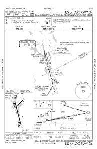
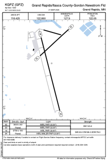


KGPZ - Grand Rapids/Itasca County-Gordon Newstrom Fld
Located in Grand Rapids, United States
ICAO - GPZ, IATA - GPZ
Data provided by AirmateGeneral information
Coordinates: N47°12'33" W93°30'36"
Elevation is 1355 feet MSL.
Magnetic variation is 02° East View others Airports in Minnesota
Operational data
Special qualification required
Current time UTC:
Current local time:
Weather
METAR: KGPZ 290256Z AUTO VRB06G14KT 6SM UP BR BKN010 OVC015 01/00 A2998 RMK AO2 RAE49UPB49 CIG 008V012 SLP170 P0006 60015 T00110000 55008 FZRANO
Communications frequencies: [VIEW]
Runways:
| RWY identifier | QFU | Length (ft) | Width (ft) | Surface | LDA (ft) |
| 05 | 47° | 3000 | 60 | ASPH | |
| 23 | 227° | 3000 | 60 | ASPH | |
| 16 | 166° | 5756 | 100 | ASPH | |
| 34 | 346° | 5756 | 100 | ASPH |
Airport contact information
Address: Grand Rapids United States
