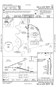
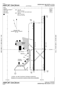


KGLH - Greenville Mid-Delta
Located in Greenville, United States
ICAO - GLH, IATA - GLH
Data provided by AirmateGeneral information
Coordinates: N33°28'58" W90°59'8"
Elevation is 130 feet MSL.
Magnetic variation is 03° East View others Airports in Mississippi
Operational data
Special qualification required
Current time UTC:
Current local time:
Weather
TAF: KGLH 290047Z 2901/2924 15015G26KT P6SM SCT035 BKN070 FM290400 15013KT P6SM OVC045 FM290700 17014KT P6SM VCTS BKN015CB OVC035 FM291000 16013KT 4SM -SHRA VCTS BKN015CB OVC045 FM291500 19014KT 6SM -SHRA OVC015 FM292200 21011KT P6SM VCSH BKN018 OVC040
Communications frequencies: [VIEW]
Runways:
| RWY identifier | QFU | Length (ft) | Width (ft) | Surface | LDA (ft) |
| 18R | 180° | 7019 | 150 | OTHER | |
| 36L | 360° | 7019 | 150 | OTHER | |
| 18L | 180° | 8001 | 150 | ASPH | 7981 |
| 36R | 0° | 8001 | 150 | ASPH | 8001 |
Airport contact information
Address: Greenville United States