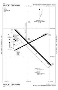


KGLD - Renner Fld/Goodland Muni
Located in Goodland, United States
ICAO - GLD, IATA - GLD
Data provided by AirmateGeneral information
Coordinates: N39°22'15" W101°41'55"
Elevation is 3657 feet MSL.
Magnetic variation is 09° East View others Airports in Kansas
Operational data
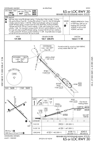
Special qualification required
Current time UTC:
Current local time:
Weather
METAR: KGLD 301953Z AUTO 14004KT 10SM BKN047 26/13 A2997 RMK AO2 SLP108 T02560128
TAF: KGLD 301720Z 3018/3118 18008KT P6SM BKN060 FM302000 VRB06KT P6SM BKN050 FM302300 10008KT P6SM BKN050 FM310200 10009KT P6SM VCTS BKN050CB TEMPO 3102/3105 VRB28G43KT 5SM -TSRA FM310600 13007KT P6SM BKN050 FM311200 01007KT P6SM SCT003 BKN080 FM311500 06009KT P6SM SCT008 BKN080 FM311700 10009KT P6SM SCT020 SCT080
Communications frequencies: [VIEW]
Runways:
| RWY identifier | QFU | Length (ft) | Width (ft) | Surface | LDA (ft) |
| 05 | 63° | 4001 | 75 | ASPH | |
| 23 | 243° | 4001 | 75 | ASPH | |
| 12 | 134° | 5499 | 100 | CONC | |
| 30 | 314° | 5499 | 100 | CONC | |
| 17 | 180° | 1754 | 40 | GRASS | |
| 35 | 360° | 1754 | 40 | GRASS |
Airport contact information
Address: Goodland United States
