


KGKY - Arlington Muni
Located in Arlington, United States
ICAO - GKY, IATA -
Data provided by AirmateGeneral information
Coordinates: N32°39'50" W97°5'39"
Elevation is 628 feet MSL.
Magnetic variation is 06° East View others Airports in Texas
Operational data
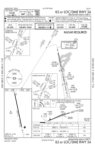
Special qualification required
Current time UTC:
Current local time:
Weather
METAR: KGKY 300453Z AUTO 00000KT 10SM CLR 18/17 A2990 RMK AO2 SLP117 T01830167 $
TAF: KGKY 300308Z 3003/3024 13008KT P6SM FEW035 FM301100 17005KT P6SM BKN025 TEMPO 3011/3015 5SM BR BKN010 FM301500 17012KT P6SM SCT025
Communications frequencies: [VIEW]
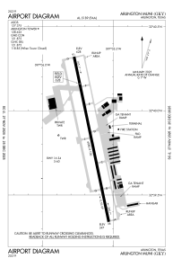
Runways:
| RWY identifier | QFU | Length (ft) | Width (ft) | Surface | LDA (ft) |
| 16 | 168° | 6080 | 100 | CONC | |
| 34 | 348° | 6080 | 100 | CONC |
Airport contact information
Address: Arlington United States
