


KGAG - Gage
Located in Gage, United States
ICAO - GAG, IATA - GAG
Data provided by AirmateGeneral information
Coordinates: N36°17'45" W99°46'35"
Elevation is 2223 feet MSL.
Magnetic variation is 08° East View others Airports in Oklahoma
Operational data
Special qualification required
Current time UTC:
Current local time:
Weather
METAR: KGAG 051016Z AUTO 06008KT 8SM OVC004 13/12 A2998 RMK AO2 CIG 003V008 T01280117 $
Communications frequencies: [VIEW]
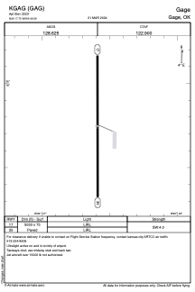
Runways:
| RWY identifier | QFU | Length (ft) | Width (ft) | Surface | LDA (ft) |
| 17 | 180° | 5033 | 75 | ASPH | |
| 35 | 360° | 5033 | 75 | ASPH |
Airport contact information
Address: Gage United States