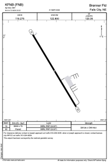


KFNB - Brenner Fld
Located in Falls City, United States
ICAO - FNB, IATA -
Data provided by AirmateGeneral information
Coordinates: N40°4'44" W95°35'31"
Elevation is 984 feet MSL.
Magnetic variation is 03° East View others Airports in Nebraska
Operational data
Special qualification required
Current time UTC:
Current local time:
Weather
METAR: KFNB 271953Z AUTO 03007KT 10SM VCTS BKN022 BKN027 OVC110 19/16 A2973 RMK AO2 LTG DSNT ALQDS RAE03B19E49 TSE36 SLP062 P0000 T01890156
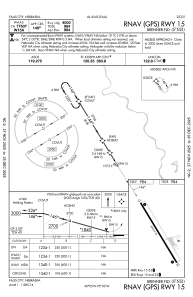
Communications frequencies: [VIEW]
Runways:
| RWY identifier | QFU | Length (ft) | Width (ft) | Surface | LDA (ft) |
| 15 | 149° | 3999 | 75 | CONC | |
| 33 | 329° | 3999 | 75 | CONC |
Airport contact information
Address: Falls City United States