


KESW - Easton State
Located in Easton, United States
ICAO - ESW, IATA - ESW
Data provided by AirmateGeneral information
Coordinates: N47°15'15" W121°11'8"
Elevation is 2226 feet MSL.
Magnetic variation is 20° East View others Airports in Washington
Operational data
Special qualification required
Current time UTC:
Current local time:
Weather at : KELN - Bowers Fld ( 55 km )
METAR: KELN 292253Z AUTO 31023G36KT 10SM CLR 12/M01 A2995 RMK AO2 PK WND 31037/2222 SLP148 T01171011
Communications frequencies: [VIEW]
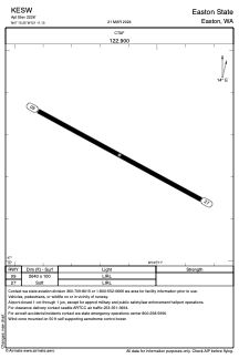
Runways:
| RWY identifier | QFU | Length (ft) | Width (ft) | Surface | LDA (ft) |
| 09 | 118° | 2640 | 100 | GRASS | |
| 27 | 298° | 2640 | 100 | GRASS |
Airport contact information
Address: Easton United States