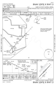
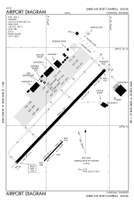


KEOD - Sabre Aaf (Fort Campbell)
Located in Fort Campbell (Clarksville), United States
ICAO - EOD, IATA -
Data provided by AirmateGeneral information
Coordinates: N36°34'4" W87°28'53"
Elevation is 595 feet MSL.
Magnetic variation is -03° East View others Airports in Tennessee
Operational data
Special qualification required
Current time UTC:
Current local time:
Weather at : KCKV - Outlaw Fld ( 8 km )
METAR: KCKV 222227Z AUTO 22006KT 2SM TSRA BR FEW065 SCT080 OVC110 19/17 A2995 RMK AO2 LTG DSNT ALQDS TSB11E26B27 P0013 T01890172 $
TAF: KCKV 222143Z 2222/2318 20005KT P6SM VCSH BKN110 TEMPO 2222/2224 2SM TSRA OVC035CB FM230000 23005KT P6SM BKN060 FM230600 19004KT P6SM SCT100 BKN250
Communications frequencies: [VIEW]
Runways:
| RWY identifier | QFU | Length (ft) | Width (ft) | Surface | LDA (ft) |
| 05 | 0° | 5000 | 100 | CONC | |
| 23 | 0° | 5000 | 100 | CONC |
Airport contact information
Address: Fort Campbell (Clarksville) United States