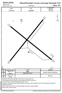


KEKN - Elkins/Randolph County (Jennings Randolph Fld)
Located in Elkins, United States
ICAO - EKN, IATA - EKN
Data provided by AirmateGeneral information
Coordinates: N38°53'22" W79°51'26"
Elevation is 1987 feet MSL.
Magnetic variation is -07° East View others Airports in West Virginia
Operational data
Special qualification required
Current time UTC:
Current local time:
Weather
METAR: KEKN 271451Z AUTO 14006KT 10SM BKN044 17/11 A3031 RMK AO2 SLP266 T01670111 51003
TAF: KEKN 271502Z 2715/2812 15008KT P6SM BKN050 FM280000 18008KT P6SM BKN080 FM280500 20006KT P6SM SCT180
Communications frequencies: [VIEW]
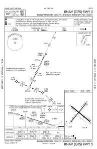
Runways:
| RWY identifier | QFU | Length (ft) | Width (ft) | Surface | LDA (ft) |
| 05 | 39° | 4501 | 75 | ASPH | |
| 23 | 219° | 4501 | 75 | ASPH | |
| 14 | 129° | 4544 | 140 | ASPH | |
| 32 | 309° | 4544 | 140 | ASPH |
Airport contact information
Address: Elkins United States