


KEGQ - Emmetsburg Muni
Located in Emmetsburg, United States
ICAO - EGQ, IATA -
Data provided by AirmateGeneral information
Coordinates: N43°6'7" W94°42'16"
Elevation is 1206 feet MSL.
Magnetic variation is 04° East View others Airports in Iowa
Operational data
Special qualification required
Current time UTC:
Current local time:
Weather at : KEST - Estherville Muni ( 34 km )
METAR: KEST 191552Z AUTO 28024G33KT 10SM FEW043 06/M03 A3019 RMK AO2 PK WND 30037/1505 SLP234 T00561028
Communications frequencies: [VIEW]
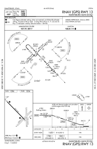
Runways:
| RWY identifier | QFU | Length (ft) | Width (ft) | Surface | LDA (ft) |
| 04 | 45° | 2537 | 120 | GRASS | |
| 22 | 225° | 2537 | 120 | GRASS | |
| 13 | 137° | 3401 | 60 | CONC | |
| 31 | 317° | 3401 | 60 | CONC | |
| 17 | 180° | 2157 | 150 | GRASS | |
| 35 | 0° | 2157 | 150 | GRASS |
Airport contact information
Address: Emmetsburg United States