


KEEN - Dillant/Hopkins
Located in Keene, United States
ICAO - EEN, IATA - EEN
Data provided by AirmateGeneral information
Coordinates: N42°53'54" W72°16'15"
Elevation is 488 feet MSL.
Magnetic variation is -15° East View others Airports in New Hampshire
Operational data
Special qualification required
Current time UTC:
Current local time:
Weather
METAR: KEEN 270456Z AUTO 00000KT 8SM CLR 14/13 A3013 RMK AO2 SLP205 T01390128 402720133 $
Communications frequencies: [VIEW]
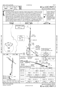
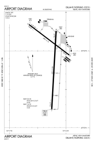
Runways:
| RWY identifier | QFU | Length (ft) | Width (ft) | Surface | LDA (ft) |
| 02 | 3° | 6201 | 100 | ASPH | |
| 20 | 183° | 6201 | 100 | ASPH | |
| 14 | 127° | 4001 | 75 | ASPH | |
| 32 | 307° | 4001 | 75 | ASPH |
Airport contact information
Address: Keene United States
