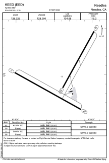


KEED - Needles
Located in Needles, United States
ICAO - EED, IATA - EED
Data provided by AirmateGeneral information
Coordinates: N34°45'59" W114°37'24"
Elevation is 983 feet MSL.
Magnetic variation is 14° East View others Airports in California
Operational data
Special qualification required
Current time UTC:
Current local time:
Weather
METAR: KEED 290056Z AUTO 07007KT 10SM CLR 31/M01 A2982 RMK AO2 SLP072 T03111011 $
TAF: KEED 282320Z 2900/2924 12007KT P6SM FEW100 FM290300 23007KT P6SM SKC FM291200 VRB05KT P6SM SKC FM291900 19012G20KT P6SM SKC
Communications frequencies: [VIEW]
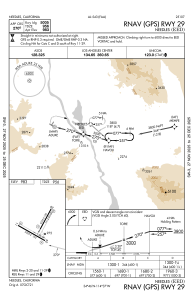
Runways:
| RWY identifier | QFU | Length (ft) | Width (ft) | Surface | LDA (ft) |
| 02 | 29° | 4235 | 100 | ASPH | |
| 20 | 209° | 4235 | 100 | ASPH | |
| 11 | 119° | 5005 | 100 | ASPH | |
| 29 | 299° | 5005 | 100 | ASPH |
Airport contact information
Address: Needles United States