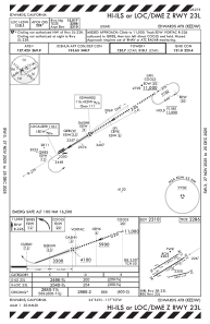
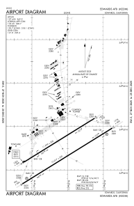


KEDW - Edwards Afb
Located in Edwards, United States
ICAO - EDW, IATA -
Data provided by AirmateGeneral information
Coordinates: N34°54'29" W117°53'8"
Elevation is 2311 feet MSL.
Magnetic variation is 12° East View others Airports in California
Operational data
Special qualification required
Current time UTC:
Current local time:
Weather
METAR: KEDW 270055Z 27019G29KT 15SM FEW050 17/02 A2980 RMK AO2A PK WND 26045/2355 PRESRR SLP082 T01700022
TAF: TAF AMD KEDW 270016Z 2700/2803 28035G45KT 8000 BLDU SCT050 SCT250 530009 QNH2976INS TEMPO 2700/2702 29040G50KT 560009 BECMG 2702/2703 29020G30KT 9999 NSW SCT250 520009 QNH2979INS TEMPO 2703/2705 29035G45KT 550009 BECMG 2708/2709 24015G25KT 9999 SCT250 520004 QNH2982INS BECMG 2715/2716 30015G25KT 9999 SCT250 520006 QNH2983INS TX21/2721Z TN08/2713Z
Communications frequencies: [VIEW]
Runways:
| RWY identifier | QFU | Length (ft) | Width (ft) | Surface | LDA (ft) |
| 05L | 0° | 12000 | 200 | ASPH | |
| 23R | 0° | 12000 | 200 | ASPH | |
| 05R | 58° | 15024 | 300 | CONC | |
| 23L | 238° | 15024 | 300 | CONC | |
| 07 | 0° | 8000 | 50 | CONC | |
| 25 | 0° | 8000 | 50 | CONC |
Airport contact information
Address: Edwards United States
