


KEAR - Kearney Rgnl
Located in Kearney, United States
ICAO - EAR, IATA - EAR
Data provided by AirmateGeneral information
Coordinates: N40°43'37" W99°0'24"
Elevation is 2131 feet MSL.
Magnetic variation is 05° East View others Airports in Nebraska
Operational data
Special qualification required
Current time UTC:
Current local time:
Weather
METAR: KEAR 280856Z AUTO 36014KT 5SM BR OVC005 09/08 A2972 RMK AO2 SLP059 60000 T00890083 56033
TAF: KEAR 280840Z 2809/2906 36011KT 5SM BR VCSH SCT003 OVC005 FM281500 33014G20KT P6SM VCSH SCT005 BKN006 FM281800 31015G22KT P6SM SCT007 BKN015 FM290000 31013G18KT P6SM BKN020 FM290300 30010KT P6SM SCT020
Communications frequencies: [VIEW]
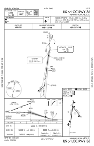
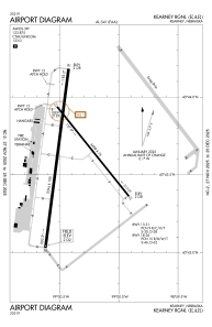
Runways:
| RWY identifier | QFU | Length (ft) | Width (ft) | Surface | LDA (ft) |
| 13 | 141° | 4498 | 75 | CONC | 4498 |
| 31 | 321° | 4498 | 75 | CONC | 4498 |
| 18 | 187° | 7094 | 100 | CONC | 7094 |
| 36 | 7° | 7094 | 100 | CONC | 7094 |
Airport contact information
Address: Kearney United States
