


KDHN - Dothan Rgnl
Located in Dothan, United States
ICAO - DHN, IATA - DHN
Data provided by AirmateGeneral information
Coordinates: N31°19'16" W85°26'58"
Elevation is 400 feet MSL.
Magnetic variation is -03° East View others Airports in Alabama
Operational data
Special qualification required
Current time UTC:
Current local time:
Weather
METAR: KDHN 281953Z 11006G14KT 9SM FEW055 27/14 A3018 RMK AO2 SLP213 T02720139
TAF: KDHN 281722Z 2818/2918 14012G18KT P6SM SCT050 SCT100 FM290000 15009KT P6SM SKC FM291100 14011KT P6SM SCT030
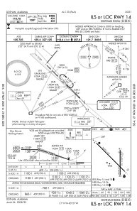
Communications frequencies: [VIEW]
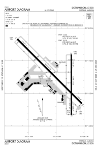
Runways:
| RWY identifier | QFU | Length (ft) | Width (ft) | Surface | LDA (ft) |
| 14 | 135° | 8499 | 150 | ASPH | 8496 |
| 32 | 315° | 8499 | 150 | ASPH | 8496 |
| 18 | 180° | 5498 | 100 | ASPH | 5000 |
| 36 | 360° | 5498 | 100 | ASPH | 5000 |
Airport contact information
Address: Dothan United States
