


KDGL - Douglas Muni
Located in Douglas, United States
ICAO - DGL, IATA - DGL
Data provided by AirmateGeneral information
Coordinates: N31°20'33" W109°30'23"
Elevation is 4173 feet MSL.
Magnetic variation is 12° East View others Airports in Arizona
Operational data
Special qualification required
Current time UTC:
Current local time:
Weather at : KDUG - Bisbee Douglas Intl ( 17 km )
METAR: KDUG 211156Z AUTO 10003KT 10SM CLR 12/M03 A2999 RMK AO2 SLP093 T01221028 10161 20111 55002 TSNO
TAF: KDUG 211120Z 2112/2212 VRB04KT P6SM SKC FM211700 22011KT P6SM SKC FM212000 25018G28KT P6SM SKC FM220300 35008KT P6SM SKC
Communications frequencies: [VIEW]
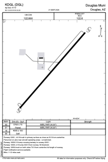
Runways:
| RWY identifier | QFU | Length (ft) | Width (ft) | Surface | LDA (ft) |
| 03 | 0° | 5760 | 75 | ASPH | |
| 21 | 0° | 5760 | 75 | ASPH | |
| 18 | 0° | 4095 | 100 | EARTH | |
| 36 | 0° | 4095 | 100 | EARTH |
Airport contact information
Address: Douglas United States