


KDDC - Dodge City Rgnl
Located in Dodge City, United States
ICAO - DDC, IATA - DDC
Data provided by AirmateGeneral information
Coordinates: N37°45'47" W99°57'56"
Elevation is 2595 feet MSL.
Magnetic variation is 08° East View others Airports in Kansas
Operational data
Special qualification required
Current time UTC:
Current local time:
Weather
METAR: KDDC 250552Z AUTO 11009KT 10SM CLR 14/04 A2988 RMK AO2 SLP096 T01440039 10256 20128 402670111 58002
TAF: KDDC 250537Z 2506/2606 VRB06KT P6SM SKC FM251200 15012KT P6SM FEW250 FM251400 17020G30KT P6SM SCT250 FM260200 22013KT P6SM SCT150
Communications frequencies: [VIEW]
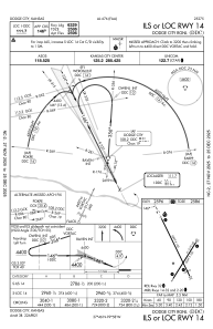
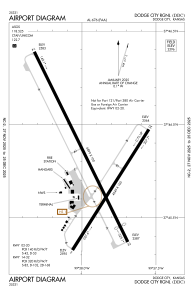
Runways:
| RWY identifier | QFU | Length (ft) | Width (ft) | Surface | LDA (ft) |
| 02 | 32° | 4649 | 100 | ASPH | 4649 |
| 20 | 212° | 4649 | 100 | ASPH | 4649 |
| 14 | 154° | 6899 | 100 | ASPH | 6329 |
| 32 | 334° | 6899 | 100 | ASPH | 6329 |
Airport contact information
Address: Dodge City United States
