


KDCY - Daviess County
Located in Washington, United States
ICAO - DCY, IATA -
Data provided by AirmateGeneral information
Coordinates: N38°42'3" W87°7'53"
Elevation is 472 feet MSL.
Magnetic variation is -03° East View others Airports in Indiana
Operational data
Special qualification required
Current time UTC:
Current local time:
Weather
METAR: KDCY 291555Z AUTO 17008KT 10SM BKN034 22/14 A2995 RMK AO2 T02190144
Communications frequencies: [VIEW]
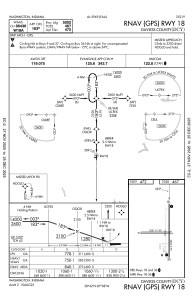
Runways:
| RWY identifier | QFU | Length (ft) | Width (ft) | Surface | LDA (ft) |
| 09 | 89° | 2651 | 150 | GRASS | |
| 27 | 271° | 2651 | 150 | GRASS | |
| 18 | 180° | 5001 | 75 | ASPH | |
| 36 | 360° | 5001 | 75 | ASPH |
Airport contact information
Address: Washington United States