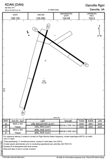


KDAN - Danville Rgnl
Located in Danville, United States
ICAO - DAN, IATA - DAN
Data provided by AirmateGeneral information
Coordinates: N36°34'21" W79°20'11"
Elevation is 571 feet MSL.
Magnetic variation is -09° East View others Airports in Virginia
Operational data
Special qualification required
Current time UTC:
Current local time:
Weather
METAR: KDAN 271153Z AUTO 05007KT 10SM OVC070 12/08 A3044 RMK AO2 SLP302 T01170078 10133 20111 53017
TAF: KDAN 271120Z 2712/2812 VRB03KT P6SM BKN060 OVC080 FM271300 VRB04KT P6SM OVC045 FM271800 20006KT P6SM OVC060 FM272200 19003KT P6SM BKN100
Communications frequencies: [VIEW]
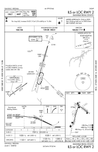
Runways:
| RWY identifier | QFU | Length (ft) | Width (ft) | Surface | LDA (ft) |
| 02 | 16° | 5900 | 100 | ASPH | 5600 |
| 20 | 196° | 5900 | 100 | ASPH | 5600 |
| 13 | 125° | 3910 | 100 | ASPH | |
| 31 | 305° | 3910 | 100 | ASPH |
Airport contact information
Address: Danville United States
