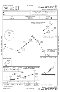
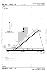


KDAG - Barstow-Daggett
Located in Daggett, United States
ICAO - DAG, IATA - DAG
Data provided by AirmateGeneral information
Coordinates: N34°51'13" W116°47'12"
Elevation is 1930 feet MSL.
Magnetic variation is 15° East View others Airports in California
Operational data
Special qualification required
Current time UTC:
Current local time:
Weather
METAR: KDAG 250750Z AUTO 25023G33KT 10SM CLR 16/06 A2990 RMK AO2 PK WND 26034/0700 SLP106 T01560056 402830128
TAF: KDAG 250520Z 2506/2606 26025G35KT P6SM BKN200 FM250900 26025G35KT P6SM SCT040 BKN150 FM251800 26025G35KT P6SM FEW050 SCT150
Communications frequencies: [VIEW]
Runways:
| RWY identifier | QFU | Length (ft) | Width (ft) | Surface | LDA (ft) |
| 04 | 51° | 5123 | 100 | ASPH | |
| 22 | 231° | 5123 | 100 | ASPH | |
| 08 | 90° | 6402 | 150 | ASPH | |
| 26 | 270° | 6402 | 150 | ASPH |
Airport contact information
Address: Daggett United States