


KCXO - Conroe/North Houston Rgnl
Located in Houston, United States
ICAO - CXO, IATA - CXO
Data provided by AirmateGeneral information
Coordinates: N30°21'12" W95°24'54"
Elevation is 244 feet MSL.
Magnetic variation is 05° East View others Airports in Texas
Operational data
Special qualification required
Current time UTC:
Current local time:
Weather
METAR: KCXO 282316Z 14011G18KT 4SM -RA BR OVC013 24/23 A2978 RMK AO2 LTG DSNT N AND NW P0001 T02390228
TAF: KCXO 282320Z 2900/2924 14016KT 6SM SHRA BR VCTS BKN015 OVC025CB TEMPO 2901/2904 4SM TSRA FM290400 16013KT 6SM SHRA BR VCTS SCT015 OVC035CB TEMPO 2905/2909 1 1/2SM TSRA BKN015CB FM291000 20005KT 6SM BR BKN008 BKN015 FM291500 28006KT P6SM BKN015 FM291700 29006KT P6SM SCT025 BKN035 FM292100 35007KT P6SM SCT060
Communications frequencies: [VIEW]
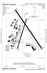
Runways:
| RWY identifier | QFU | Length (ft) | Width (ft) | Surface | LDA (ft) |
| 01 | 17° | 5000 | 100 | CONC | 5000 |
| 19 | 197° | 5000 | 100 | CONC | 5000 |
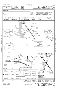
| 14 | 145° | 7501 | 150 | CONC | |
| 32 | 325° | 7501 | 150 | CONC |
Airport contact information
Address: Houston United States
