


KCVG - Cincinnati/Northern Kentucky Intl
Located in Covington, United States
ICAO - CVG, IATA - CVG
Data provided by AirmateGeneral information
Coordinates: N39°2'56" W84°40'4"
Elevation is 896 feet MSL.
Magnetic variation is -06° East View others Airports in Kentucky
Operational data
Special qualification required
Current time UTC:
Current local time:
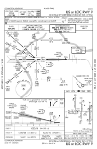
Communications frequencies: [VIEW]
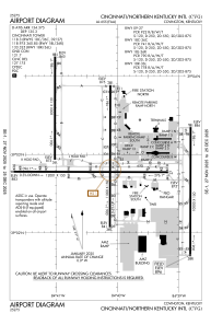
Runways:
| RWY identifier | QFU | Length (ft) | Width (ft) | Surface | LDA (ft) |
| 09 | 90° | 12001 | 150 | OTHER | 11640 |
| 27 | 270° | 12001 | 150 | OTHER | 12000 |
| 18C | 180° | 11000 | 150 | OTHER | |
| 36C | 0° | 11000 | 150 | OTHER | |
| 18L | 180° | 10000 | 150 | CONC | |
| 36R | 0° | 10000 | 150 | CONC | |
| 18R | 180° | 8000 | 150 | CONC | |
| 36L | 0° | 8000 | 150 | CONC |
Airport contact information
Address: Covington United States
