


KCPS - St Louis Downtown
Located in Cahokia/St Louis, United States
ICAO - CPS, IATA - CPS
Data provided by AirmateGeneral information
Coordinates: N38°34'13" W90°9'18"
Elevation is 412 feet MSL.
Magnetic variation is 00° East View others Airports in Illinois
Operational data
Special qualification required
Current time UTC:
Current local time:
Weather
METAR: KCPS 281153Z 16009KT 10SM CLR 20/17 A2992 RMK AO2 SLP127 70007 T02000167 10211 20200 51007 $
TAF: KCPS 281148Z 2812/2912 17012KT P6SM BKN150 FM281500 18015G26KT P6SM BKN100 FM290000 18012G23KT P6SM VCSH BKN070 FM290600 20012G20KT 6SM SHRA BR VCTS OVC025CB
Communications frequencies: [VIEW]
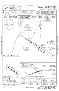
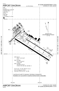
Runways:
| RWY identifier | QFU | Length (ft) | Width (ft) | Surface | LDA (ft) |
| 12R | 122° | 7002 | 150 | ASPH | 7002 |
| 30L | 302° | 7002 | 150 | ASPH | 7002 |
| 12L | 122° | 5301 | 75 | CONC | 5300 |
| 30R | 302° | 5301 | 75 | CONC | 5300 |
| 05 | 47° | 2799 | 75 | ASPH | 2799 |
| 23 | 227° | 2799 | 75 | ASPH | 2799 |
Airport contact information
Address: Cahokia/St Louis United States

