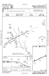
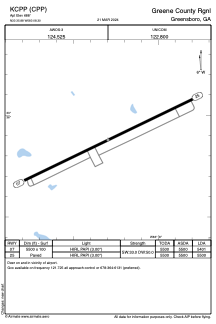


KCPP - Greene County Rgnl
Located in Greensboro, United States
ICAO - CPP, IATA -
Data provided by AirmateGeneral information
Coordinates: N33°35'53" W83°8'18"
Elevation is 688 feet MSL.
Magnetic variation is -05° East View others Airports in Georgia
Operational data
Special qualification required
Current time UTC:
Current local time:
Weather at : KIIY - Washington/Wilkes County ( 36 km )
METAR: KIIY 290815Z AUTO 15006KT 10SM CLR 13/12 A3016 RMK AO2 T01320118
Communications frequencies: [VIEW]
Runways:
| RWY identifier | QFU | Length (ft) | Width (ft) | Surface | LDA (ft) |
| 07 | 64° | 5500 | 100 | ASPH | 5401 |
| 25 | 244° | 5500 | 100 | ASPH | 5500 |
Airport contact information
Address: Greensboro United States