


KCOU - Columbia Rgnl
Located in Columbia, United States
ICAO - COU, IATA - COU
Data provided by AirmateGeneral information
Coordinates: N38°49'4" W92°13'4"
Elevation is 889 feet MSL.
Magnetic variation is 00° East View others Airports in Missouri
Operational data
Special qualification required
Current time UTC:
Current local time:
Weather
METAR: KCOU 280854Z AUTO 06009KT 10SM OVC033 16/16 A2984 RMK AO2 SLP098 60025 T01610156 56013
TAF: KCOU 280522Z 2806/2906 17011G20KT 6SM SHRA BR VCTS OVC040CB FM281000 16009KT 6SM SHRA BR VCTS OVC025CB FM281500 16017G26KT P6SM VCSH OVC015 FM281900 18018G28KT 6SM SHRA BR VCTS OVC020CB FM290400 18010G21KT P6SM VCSH BKN035
Communications frequencies: [VIEW]
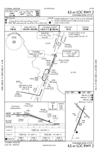
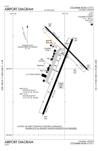
Runways:
| RWY identifier | QFU | Length (ft) | Width (ft) | Surface | LDA (ft) |
| 02 | 21° | 7401 | 150 | CONC | 6501 |
| 20 | 201° | 7401 | 150 | CONC | 6501 |
| 13 | 135° | 5500 | 100 | CONC | 5500 |
| 31 | 315° | 5500 | 100 | CONC | 5500 |
Airport contact information
Address: Columbia United States
