


KCLE - Cleveland-Hopkins Intl
Located in Cleveland, United States
ICAO - CLE, IATA - CLE
Data provided by AirmateGeneral information
Coordinates: N41°24'34" W81°51'17"
Elevation is 799 feet MSL.
Magnetic variation is -08° East View others Airports in Ohio
Operational data
Special qualification required
Current time UTC:
Current local time:
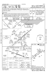
Communications frequencies: [VIEW]
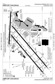
Runways:
| RWY identifier | QFU | Length (ft) | Width (ft) | Surface | LDA (ft) |
| 06L | 50° | 9000 | 150 | CONC | 9000 |
| 24R | 230° | 9000 | 150 | CONC | 9000 |
| 06R | 50° | 9953 | 150 | CONC | 8029 |
| 24L | 230° | 9953 | 150 | CONC | 9956 |
| 10 | 93° | 6018 | 150 | OTHER | 6018 |
| 28 | 273° | 6018 | 150 | OTHER | 6018 |
Airport contact information
Address: Cleveland United States