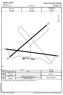


KCKF - Crisp County-Cordele
Located in Cordele, United States
ICAO - CKF, IATA -
Data provided by AirmateGeneral information
Coordinates: N31°59'20" W83°46'26"
Elevation is 309 feet MSL.
Magnetic variation is -06° East View others Airports in Georgia
Operational data
Special qualification required
Current time UTC:
Current local time:
Weather
METAR: KCKF 012155Z AUTO 36004KT 10SM SCT065 SCT100 30/13 A2993 RMK AO2 T03020133
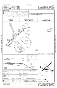
Communications frequencies: [VIEW]
Runways:
| RWY identifier | QFU | Length (ft) | Width (ft) | Surface | LDA (ft) |
| 06 | 50° | 5006 | 100 | ASPH | |
| 24 | 230° | 5006 | 100 | ASPH | |
| 10 | 98° | 5001 | 150 | ASPH | |
| 28 | 278° | 5001 | 150 | ASPH |
Airport contact information
Address: Cordele United States