


KCID - The Eastern Iowa
Located in Cedar Rapids, United States
ICAO - CID, IATA - CID
Data provided by AirmateGeneral information
Coordinates: N41°53'5" W91°42'39"
Elevation is 869 feet MSL.
Magnetic variation is 02° East View others Airports in Iowa
Operational data
Special qualification required
Current time UTC:
Current local time:
Weather
METAR: KCID 270552Z AUTO 16020G31KT 10SM BKN018 OVC023 17/14 A2958 RMK AO2 PK WND 16039/0458 SLP015 T01720144 10178 20133 401780078 58009
TAF: KCID 270520Z 2706/2806 15019G29KT P6SM OVC025 FM271000 18016G24KT P6SM OVC015 FM271800 22015G24KT P6SM BKN025 PROB30 2721/2803 VRB20G40KT 2SM TSRA BR BKN010CB
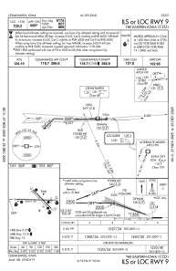
Communications frequencies: [VIEW]
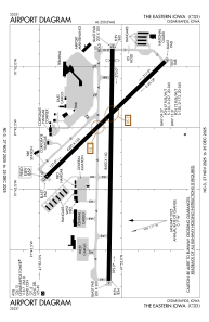
Runways:
| RWY identifier | QFU | Length (ft) | Width (ft) | Surface | LDA (ft) |
| 09 | 91° | 8600 | 150 | CONC | 8175 |
| 27 | 271° | 8600 | 150 | CONC | 8175 |
| 13 | 136° | 6200 | 150 | CONC | 6200 |
| 31 | 316° | 6200 | 150 | CONC | 6200 |
Airport contact information
Address: Cedar Rapids United States
