


KCHO - Charlottesville-Albemarle
Located in Charlottesville, United States
ICAO - CHO, IATA - CHO
Data provided by AirmateGeneral information
Coordinates: N38°8'23" W78°27'8"
Elevation is 640 feet MSL.
Magnetic variation is -08° East View others Airports in Virginia
Operational data
Special qualification required
Current time UTC:
Current local time:
Weather
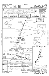
METAR: KCHO 271053Z 00000KT 10SM -RA OVC031 11/07 A3044 RMK AO2 RAB10 SLP305 P0000 T01110072
TAF: KCHO 270531Z 2706/2806 16005KT P6SM OVC045 FM271000 11004KT P6SM VCSH SCT010 OVC030 FM271400 15004KT 6SM -SHRA BR SCT008 OVC015 FM271800 16006KT P6SM SCT008 OVC020 FM272100 16006KT P6SM SCT010 BKN035 FM280000 15005KT P6SM BKN050
Communications frequencies: [VIEW]
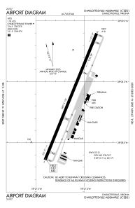
Runways:
| RWY identifier | QFU | Length (ft) | Width (ft) | Surface | LDA (ft) |
| 03 | 22° | 6801 | 150 | ASPH | 6801 |
| 21 | 202° | 6801 | 150 | ASPH | 6801 |
Airport contact information
Address: Charlottesville United States
