


KCFV - Coffeyville Muni
Located in Coffeyville, United States
ICAO - CFV, IATA - CFV
Data provided by AirmateGeneral information
Coordinates: N37°5'38" W95°34'19"
Elevation is 754 feet MSL.
Magnetic variation is 05° East View others Airports in Kansas
Operational data
Special qualification required
Current time UTC:
Current local time:
Weather
METAR: KCFV 271952Z AUTO 17012G19KT 10SM CLR 26/19 A2974 RMK AO2 PK WND 19026/1922 SLP064 T02560189
Communications frequencies: [VIEW]
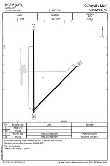
Runways:
| RWY identifier | QFU | Length (ft) | Width (ft) | Surface | LDA (ft) |
| 04 | 45° | 4005 | 75 | ASPH | |
| 22 | 225° | 4005 | 75 | ASPH | |
| 17 | 180° | 5868 | 100 | ASPH | |
| 35 | 360° | 5868 | 100 | ASPH |
Airport contact information
Address: Coffeyville United States