


KCDA - Caledonia County
Located in Lyndonville, United States
ICAO - CDA, IATA - LLX
Data provided by AirmateGeneral information
Coordinates: N44°34'9" W72°1'5"
Elevation is 1187 feet MSL.
Magnetic variation is -16° East View others Airports in Vermont
Operational data
Special qualification required
Current time UTC:
Current local time:
Weather
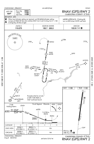
METAR: KCDA 150515Z AUTO 02005KT 7SM -RA SCT060 SCT070 OVC080 14/13 A2991 RMK AO2 T01400132
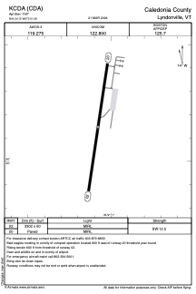
Communications frequencies: [VIEW]
Runways:
| RWY identifier | QFU | Length (ft) | Width (ft) | Surface | LDA (ft) |
| 02 | 8° | 3302 | 60 | ASPH | |
| 20 | 188° | 3302 | 60 | ASPH |
Airport contact information
Address: Lyndonville United States