


KCAK - Akron-Canton Rgnl
Located in Akron, United States
ICAO - CAK, IATA - CAK
Data provided by AirmateGeneral information
Coordinates: N40°54'54" W81°26'37"
Elevation is 1225 feet MSL.
Magnetic variation is -07° East View others Airports in Ohio
Operational data
Special qualification required
Current time UTC:
Current local time:
Weather
METAR: KCAK 170451Z 00000KT 10SM FEW060 SCT250 16/13 A2985 RMK AO2 SLP102 T01610128 402500111
TAF: KCAK 162339Z 1700/1724 36003KT P6SM FEW060 BKN080 BKN100 FM171000 18006KT 6SM -SHRA OVC028 FM171200 17005KT 4SM -SHRA OVC009 FM171500 18006KT 6SM -SHRA OVC012 FM171800 21008KT P6SM OVC022 FM172200 23006KT P6SM BKN045
Communications frequencies: [VIEW]
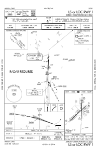
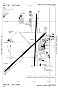
Runways:
| RWY identifier | QFU | Length (ft) | Width (ft) | Surface | LDA (ft) |
| 01 | 2° | 7601 | 150 | ASPH | 7007 |
| 19 | 182° | 7601 | 150 | ASPH | 7007 |
| 05 | 47° | 8204 | 150 | ASPH | 8204 |
| 23 | 227° | 8204 | 150 | ASPH | 8204 |
Airport contact information
Address: Akron United States
