


KCAK - Akron-Canton Rgnl
Located in Akron, United States
ICAO - CAK, IATA - CAK
Data provided by AirmateGeneral information
Coordinates: N40°54'54" W81°26'37"
Elevation is 1225 feet MSL.
Magnetic variation is -07° East View others Airports in Ohio
Operational data
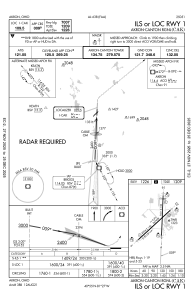
Special qualification required
Current time UTC:
Current local time:
Weather
TAF: KCAK 271457Z 2715/2812 19015G25KT P6SM SCT070 BKN100 FM271700 22016G24KT P6SM BKN040 FM280000 20010KT P6SM BKN100
Communications frequencies: [VIEW]
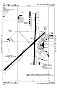
Runways:
| RWY identifier | QFU | Length (ft) | Width (ft) | Surface | LDA (ft) |
| 01 | 2° | 7601 | 150 | ASPH | 7007 |
| 19 | 182° | 7601 | 150 | ASPH | 7007 |
| 05 | 47° | 8204 | 150 | ASPH | 8204 |
| 23 | 227° | 8204 | 150 | ASPH | 8204 |
Airport contact information
Address: Akron United States
