


KCAE - Columbia Metro
Located in Columbia, United States
ICAO - CAE, IATA - CAE
Data provided by AirmateGeneral information
Coordinates: N33°56'20" W81°7'10"
Elevation is 236 feet MSL.
Magnetic variation is -07° East View others Airports in South Carolina
Operational data
Special qualification required
Current time UTC:
Current local time:
Weather
METAR: KCAE 070656Z 14006KT 10SM BKN022 21/18 A2992 RMK AO2 SLP128 CB DSNT NE T02060178
TAF: KCAE 070520Z 0706/0806 20004KT P6SM SCT120 TEMPO 0709/0713 3SM BR SCT007 OVC015 FM071400 24008KT P6SM SCT040 SCT250 FM071800 24011G19KT P6SM FEW060 SCT250 FM080200 VRB04KT P6SM FEW200
Communications frequencies: [VIEW]
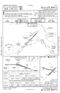
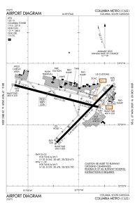
Runways:
| RWY identifier | QFU | Length (ft) | Width (ft) | Surface | LDA (ft) |
| 05 | 45° | 8001 | 150 | OTHER | 7001 |
| 23 | 225° | 8001 | 150 | OTHER | 7001 |
| 11 | 105° | 8601 | 150 | CONC | 8601 |
| 29 | 285° | 8601 | 150 | CONC | 8506 |
| H1 | 0° | 0 | 0 | UNK |
Airport contact information
Address: Columbia United States