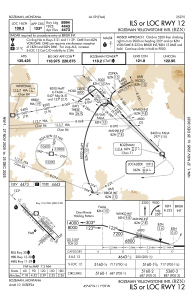
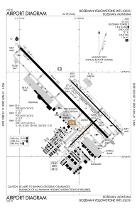


KBZN - Bozeman Yellowstone Intl
Located in Bozeman, United States
ICAO - BZN, IATA - BZN
Data provided by AirmateGeneral information
Coordinates: N45°46'38" W111°9'1"
Elevation is 4473 feet MSL.
Magnetic variation is 13° East View others Airports in Montana
Operational data
Special qualification required
Current time UTC:
Current local time:
Weather
METAR: KBZN 141756Z 34016G23KT 10SM OVC041 11/07 A3002 RMK AO2 SLP147 T01060067 10156 20078 53003
TAF: KBZN 141720Z 1418/1524 34009KT P6SM VCTS BKN050CB FM142000 32009KT 6SM -SHRA BR VCTS BKN070CB TEMPO 1420/1424 4SM -SHRA BR OVC025 FM150300 VRB06KT P6SM VCTS BKN070CB PROB30 1503/1505 4SM -SHRA BR BKN060 FM151100 VRB04KT P6SM BKN050 FM152000 27008KT P6SM SCT180
Communications frequencies: [VIEW]
Runways:
| RWY identifier | QFU | Length (ft) | Width (ft) | Surface | LDA (ft) |
| 03 | 46° | 2650 | 75 | ASPH | 2650 |
| 21 | 226° | 2650 | 75 | ASPH | 2650 |
| 11 | 136° | 5050 | 75 | ASPH | 5050 |
| 29 | 316° | 5050 | 75 | ASPH | 5050 |
| 11G | 136° | 2802 | 80 | GRASS | |
| 29G | 316° | 2802 | 80 | GRASS | |
| 12 | 136° | 8994 | 150 | ASPH | 8994 |
| 30 | 316° | 8994 | 150 | ASPH | 8994 |
Airport contact information
Address: Bozeman United States

