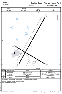


KBWG - Bowling Green-Warren County Rgnl
Located in Bowling Green, United States
ICAO - BWG, IATA - BWG
Data provided by AirmateGeneral information
Coordinates: N36°57'52" W86°25'11"
Elevation is 547 feet MSL.
Magnetic variation is -04° East View others Airports in Kentucky
Operational data
Special qualification required
Current time UTC:
Current local time:
Weather
METAR: KBWG 151853Z AUTO 30008KT 270V330 10SM FEW016 SCT031 BKN038 23/18 A2974 RMK AO2 SLP068 T02280178
TAF: KBWG 151731Z 1518/1618 28010KT P6SM VCTS SCT007 BKN025CB FM152200 29007KT P6SM VCTS BKN050CB FM160000 VRB04KT P6SM SCT050 FM160700 00000KT 4SM BR OVC015 FM160900 00000KT 1SM BR OVC004 FM161400 29004KT P6SM BKN035
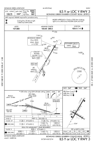
Communications frequencies: [VIEW]
Runways:
| RWY identifier | QFU | Length (ft) | Width (ft) | Surface | LDA (ft) |
| 03 | 30° | 6501 | 150 | ASPH | |
| 21 | 210° | 6501 | 150 | ASPH | |
| 12 | 120° | 3956 | 150 | ASPH | |
| 30 | 300° | 3956 | 150 | ASPH |
Airport contact information
Address: Bowling Green United States
