


KBUR - Bob Hope
Located in Burbank, United States
ICAO - BUR, IATA - BUR
Data provided by AirmateGeneral information
Coordinates: N34°12'2" W118°21'31"
Elevation is 778 feet MSL.
Magnetic variation is 12° East View others Airports in California
Operational data
Special qualification required
Current time UTC:
Current local time:
Weather
METAR: KBUR 190553Z 19005KT 10SM CLR 14/11 A2998 RMK AO2 SLP144 T01390111 10211 20139 51011
TAF: KBUR 190532Z 1906/2006 14004KT P6SM SKC FM190830 VRB03KT 5SM BR OVC007 FM191500 16004KT 5SM BR OVC012 FM191700 17006KT P6SM BKN017 FM192000 18010KT P6SM SCT020
Communications frequencies: [VIEW]
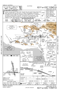
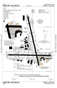
Runways:
| RWY identifier | QFU | Length (ft) | Width (ft) | Surface | LDA (ft) |
| 08 | 91° | 5802 | 150 | OTHER | 5801 |
| 26 | 271° | 5802 | 150 | OTHER | 5801 |
| 15 | 167° | 6886 | 150 | OTHER | 5976 |
| 33 | 347° | 6886 | 150 | OTHER | 6535 |
Airport contact information
Address: Burbank United States
