


KBTR - Baton Rouge Metro, Ryan Fld
Located in Baton Rouge, United States
ICAO - BTR, IATA - BTR
Data provided by AirmateGeneral information
Coordinates: N30°31'59" W91°8'60"
Elevation is 69 feet MSL.
Magnetic variation is 00° East View others Airports in Louisiana
Operational data
Special qualification required
Current time UTC:
Current local time:
Weather
METAR: KBTR 171053Z 13008KT 10SM BKN009 OVC014 23/21 A2970 RMK AO2 CIG 007V011 SLP055 T02280211
TAF: KBTR 170827Z 1708/1806 10010KT P6SM BKN008 BKN035 FM171000 12010KT 5SM BR BKN010 BKN020 FM171400 14007KT P6SM BKN015 BKN050 FM171800 25008KT P6SM BKN020 FM180000 VRB04KT P6SM SCT020 OVC035
Communications frequencies: [VIEW]
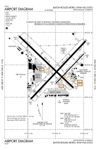
Runways:
| RWY identifier | QFU | Length (ft) | Width (ft) | Surface | LDA (ft) |
| 04L | 43° | 7500 | 150 | CONC | 7500 |
| 22R | 223° | 7500 | 150 | CONC | 7500 |
| 04R | 43° | 3799 | 75 | ASPH | 3799 |
| 22L | 223° | 3799 | 75 | ASPH | 3799 |
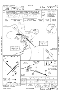
| 13 | 133° | 7005 | 150 | ASPH | 5720 |
| 31 | 313° | 7005 | 150 | ASPH | 6094 |
Airport contact information
Address: Baton Rouge United States

