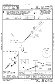
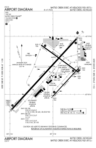


KBTL - Battle Creek Exec At Kellogg Fld
Located in Battle Creek, United States
ICAO - BTL, IATA - BTL
Data provided by AirmateGeneral information
Coordinates: N42°18'23" W85°15'0"
Elevation is 951 feet MSL.
Magnetic variation is -04° East View others Airports in Michigan
Operational data
Special qualification required
Current time UTC:
Current local time:
Weather
METAR: KBTL 081753Z 29011G21KT 270V330 10SM CLR 23/07 A2974 RMK AO2 SLP066 T02330072 10239 20139 52007 $
TAF: KBTL 081740Z 0818/0918 26010KT P6SM SKC FM081900 29012KT P6SM SKC FM090000 35007KT P6SM BKN050 FM091000 08011KT P6SM OVC050 PROB30 0910/0911 P6SM -SHRA FM091100 07011KT P6SM -SHRA OVC050
Communications frequencies: [VIEW]
Runways:
| RWY identifier | QFU | Length (ft) | Width (ft) | Surface | LDA (ft) |
| 05L | 43° | 10004 | 150 | ASPH | 10004 |
| 23R | 223° | 10004 | 150 | ASPH | 10004 |
| 05R | 43° | 4100 | 75 | ASPH | 4100 |
| 23L | 223° | 4100 | 75 | ASPH | 4100 |
| 13 | 126° | 4835 | 100 | ASPH | 4835 |
| 31 | 306° | 4835 | 100 | ASPH | 4835 |
Airport contact information
Address: Battle Creek United States
