


KBTF - Skypark
Located in Bountiful, United States
ICAO - BTF, IATA - BTF
Data provided by AirmateGeneral information
Coordinates: N40°52'5" W111°55'39"
Elevation is 4237 feet MSL.
Magnetic variation is 15° East View others Airports in Utah
Operational data
Special qualification required
Current time UTC:
Current local time:
Weather at : KSLC - Salt Lake City Intl ( 10 km )
METAR: KSLC 181154Z 15003KT 10SM FEW070 FEW200 12/M02 A3004 RMK AO2 SLP130 T01171017 10172 20106 51015
TAF: KSLC 181123Z 1812/1918 16004KT P6SM FEW250 FM181700 34008KT P6SM FEW250 FM190300 14009KT P6SM FEW070 SCT120 BKN250 FM191500 32009KT P6SM SCT120 BKN250
Communications frequencies: [VIEW]
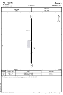
Runways:
| RWY identifier | QFU | Length (ft) | Width (ft) | Surface | LDA (ft) |
| 17 | 0° | 4634 | 70 | ASPH | |
| 35 | 0° | 4634 | 70 | ASPH |
Airport contact information
Address: Bountiful United States
