


KBRO - Brownsville/South Padre Island Intl
Located in Brownsville, United States
ICAO - BRO, IATA - BRO
Data provided by AirmateGeneral information
Coordinates: N25°54'22" W97°25'34"
Elevation is 22 feet MSL.
Magnetic variation is 03° East View others Airports in Texas
Operational data
Special qualification required
Current time UTC:
Current local time:
Weather
METAR: KBRO 270253Z 10006KT 7SM BKN012 OVC018 30/27 A2974 RMK AO2 SLP070 T03000272 51021 $
TAF: KBRO 262320Z 2700/2724 15012G20KT P6SM FEW120 FM270800 15008KT P6SM BKN015 FM271200 15008KT 3SM BR SCT008 OVC019 FM271600 15011KT 5SM HZ FEW026 OVC030 FM271800 13012KT 6SM HZ SCT250
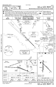
Communications frequencies: [VIEW]
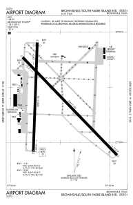
Runways:
| RWY identifier | QFU | Length (ft) | Width (ft) | Surface | LDA (ft) |
| 13 | 135° | 7399 | 150 | ASPH | 7399 |
| 31 | 315° | 7399 | 150 | ASPH | 7399 |
| 18 | 182° | 6000 | 150 | ASPH | 5810 |
| 36 | 2° | 6000 | 150 | ASPH | 5532 |
Airport contact information
Address: Brownsville United States
