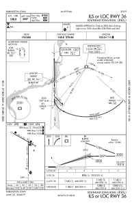
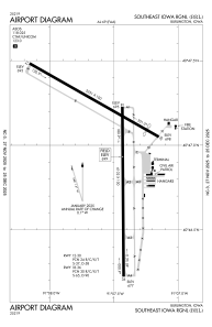


KBRL - Southeast Iowa Rgnl
Located in Burlington, United States
ICAO - BRL, IATA - BRL
Data provided by AirmateGeneral information
Coordinates: N40°46'59" W91°7'32"
Elevation is 698 feet MSL.
Magnetic variation is 01° East View others Airports in Iowa
Operational data
Special qualification required
Current time UTC:
Current local time:
Weather
METAR: KBRL 290153Z AUTO 20007KT 10SM SCT036 18/16 A2981 RMK AO2 SLP093 T01780161
TAF: KBRL 282341Z 2900/2924 20008KT P6SM SCT030 OVC060 TEMPO 2900/2903 6SM -SHRA BR BKN030 FM290600 20008KT 5SM BR OVC019 FM291200 23008KT 5SM BR OVC015 FM291600 24012G20KT P6SM SCT025 OVC060 FM291800 25015G22KT P6SM BKN250
Communications frequencies: [VIEW]
Runways:
| RWY identifier | QFU | Length (ft) | Width (ft) | Surface | LDA (ft) |
| 12 | 120° | 5351 | 100 | CONC | 5350 |
| 30 | 300° | 5351 | 100 | CONC | 4850 |
| 18 | 180° | 6102 | 100 | CONC | 6102 |
| 36 | 360° | 6102 | 100 | CONC | 6102 |
Airport contact information
Address: Burlington United States
