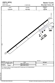


KBPK - Baxter County
Located in Mountain Home, United States
ICAO - BPK, IATA - WMH
Data provided by AirmateGeneral information
Coordinates: N36°22'8" W92°28'14"
Elevation is 928 feet MSL.
Magnetic variation is 03° East View others Airports in Arkansas
Operational data
Special qualification required
Current time UTC:
Current local time:
Weather
METAR: KBPK 291053Z AUTO 00000KT 7SM CLR 16/16 A2987 RMK AO2 RAB0955E14 SLP108 P0000 T01610156
TAF: KBPK 291126Z 2911/3012 VRB05KT P6SM VCSH OVC250 TEMPO 2912/2916 -RA OVC015 FM291800 VRB04KT P6SM OVC040 FM292200 VRB05KT P6SM OVC100
Communications frequencies: [VIEW]
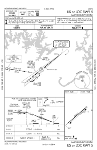
Runways:
| RWY identifier | QFU | Length (ft) | Width (ft) | Surface | LDA (ft) |
| 05 | 52° | 5000 | 75 | ASPH | |
| 23 | 232° | 5000 | 75 | ASPH |
Airport contact information
Address: Mountain Home United States
