


KBGR - Bangor Intl
Located in Bangor, United States
ICAO - BGR, IATA - BGR
Data provided by AirmateGeneral information
Coordinates: N44°48'27" W68°49'41"
Elevation is 192 feet MSL.
Magnetic variation is -16° East View others Airports in Maine
Operational data
Special qualification required
Current time UTC:
Current local time:
Weather
TAF: KBGR 060009Z 0600/0624 18009KT 6SM -SHRA BR OVC006 FM060100 18009KT 3SM -RA BR OVC005 FM060400 18008KT 5SM -SHRA BR OVC004 FM060600 18008KT P6SM VCSH OVC003 FM061500 21005KT P6SM BKN010 FM061800 25006KT P6SM SCT070
Communications frequencies: [VIEW]
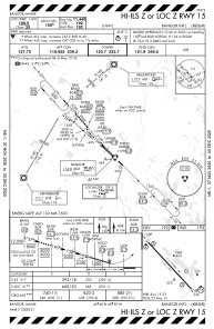
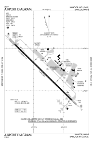
Runways:
| RWY identifier | QFU | Length (ft) | Width (ft) | Surface | LDA (ft) |
| 15 | 134° | 11440 | 200 | ASPH | 11440 |
| 33 | 314° | 11440 | 200 | ASPH | 11440 |
Airport contact information
Address: Bangor United States
Other aviation service providers
Repair station

Flight schools

Penobscot Valley Flying Club, Inc.
Penobscot Valley Flying Club, Inc.
info@maestrofligth.com+1(207)433-0116