


KBFM - Mobile Intl
Located in Mobile, United States
ICAO - BFM, IATA - BFM
Data provided by AirmateGeneral information
Coordinates: N30°37'36" W88°4'5"
Elevation is 26 feet MSL.
Magnetic variation is -01° East View others Airports in Alabama
Operational data
Special qualification required
Current time UTC:
Current local time:
Weather
METAR: KBFM 281953Z 13013KT 10SM BKN044 27/17 A3013 RMK AO2 SLP202 T02720172
TAF: KBFM 281723Z 2818/2918 15016G25KT P6SM SCT028 BKN035 OVC070 FM290300 13011KT P6SM BKN035 FM290600 13010KT P6SM BKN015 FM291600 15011G18KT P6SM BKN050
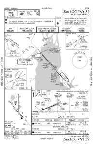
Communications frequencies: [VIEW]
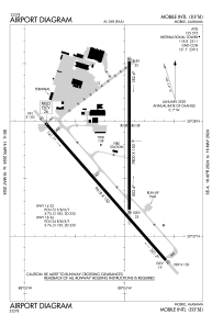
Runways:
| RWY identifier | QFU | Length (ft) | Width (ft) | Surface | LDA (ft) |
| 14 | 139° | 9618 | 150 | OTHER | |
| 32 | 319° | 9618 | 150 | OTHER | |
| 18 | 180° | 7800 | 150 | OTHER | |
| 36 | 360° | 7800 | 150 | OTHER |
Airport contact information
Address: Mobile United States