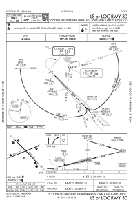
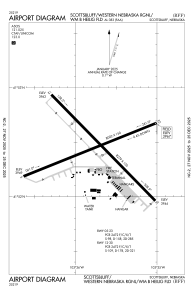


KBFF - Western Nebraska Rgnl/Wm B Heilig Fld/Scottsbluff
Located in Scottsbluff, United States
ICAO - BFF, IATA - BFF
Data provided by AirmateGeneral information
Coordinates: N41°52'27" W103°35'44"
Elevation is 3967 feet MSL.
Magnetic variation is 10° East View others Airports in Nebraska
Operational data
Special qualification required
Current time UTC:
Current local time:
Weather
METAR: KBFF 051853Z AUTO 15026G34KT 10SM CLR 20/09 A2971 RMK AO2 PK WND 14034/1853 SLP031 T02000089
TAF: KBFF 051733Z 0518/0618 14025G35KT P6SM SCT030 FM060200 12025G35KT P6SM VCTS SCT120CB FM060400 12030G40KT P6SM SCT120 FM061000 12020G30KT P6SM VCSH BKN080
Communications frequencies: [VIEW]
Runways:
| RWY identifier | QFU | Length (ft) | Width (ft) | Surface | LDA (ft) |
| 05 | 68° | 8002 | 150 | ASPH | 8002 |
| 23 | 248° | 8002 | 150 | ASPH | 8002 |
| 12 | 136° | 8279 | 150 | ASPH | 8279 |
| 30 | 316° | 8279 | 150 | ASPH | 8279 |
Airport contact information
Address: Scottsbluff United States
